
Report on the Sabai Tsho glacial lake dam broken on 3 September, 1998 : A natural disaster hitting the village of Tangnag, 20 km SSE of Mount Everest and downstream villages along the Hinku Drangkha and Dudh Kosi Rivers
CLICK on the pictures for full view.


Overview
At 5 AM in the early morning of September 3rd, 1998, disaster struck the mountainous village of Tangnag (4356 m altitude) in the Hinku Valley, 20 km SSE of the Mount Everest in Nepal and ENE of Lukla, when the glacial dam broke of the 0.5 square km Sabai Tsho Lake.
According to local inhabitants, an earth quake hit this region and caused a large piece of the glacier hanging steeply above theSabai Tsho Lake to fall in the lake some 200 - 400 m lower, see detailed photograph. From the barren rocks, it is estimated that size of the broken of slab of glacier was around 300 M HIGH, 100 m wide and 10 m thick. This still needs to be confirmed by pre September 3rd, 1998 photographs.
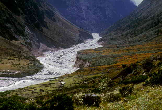
The local villagers including Lhakpa Geljen Sherpa, reported that this caused the natural glacial lake dam (moraine), 100 m high and 300 m across (thick), to burst forming a hole of 2000 square m and for the next 5 to 10 minutes, a flood of rocks, water and glacial ice burst through the dam hole, along the river valley passing the village of Tangnag, a kilometre down-stream, filling the broad river bed with a 800 by 300 m wide and around 5 to 40 m thick rubble of rock boulders up to 2 m across. The wall of water measured around 2000 square meters and rushed down the Hinku valley and was up to 10 to 12 m high in the outer bends of the around 200 m wide river bed.
Much smaller, intermittent floods continued and by 8 AM the water floods hit the first houses of Tangnag, including the local lodge (Sun Rise Lodge). The floods continued until 1 AM the same night, for a total of 20 hours, by the time the Sabai Tsho Lake measuring 1200 by 500 m, dropped its water level by 50 m. In Tangnag, two houses were swept away and three yaks were killed but no other casualties were reported. The road (path) between Thuli Kharka and Tangnag via Tashing Dingma near the river bed is washed away and travellers are now forced to take the little used, difficult, high road that before the flood was mainly used by yaks. This increases the travel between Thuli Kharka and Tangnag from 1 day to 1.5 days.
Down-stream, along the Drangkha and Dudh Kosi Rivers, bridges and houses were washed away and a number of people were killed. Various Sherpas from the region reported around 300 casualties but this is an unconfirmed figure. The Home Office of Nepal is being contacted for the official figures.
For the past few years, the Tsho Rolpa Lake in Rolwaling area of Nepal, has been targetted as a major risk but no one thought the Sabai Tsho Lake dam could burst.Field observations (to be completed)
The sudden outburst and flood of rocks is clearly confirmed by the large, 800 long and 300 m wide boulder field in front of the dam. The force to create this must have been very large and a large slab of glacial ice falling in the Sabai Tsho lake could have the energy to break the dam.
Intermittent floods are presumably due to choking of the glacial dam hole, also see detail, of around 2000 square meters by the glacial ice or continued collapse of the dam. Gravel deposits of 10 to 30 cm thick and up to 10 meters wide between the boulders confirm this.
Down-streams the around 200 to 300 m wide river bed shows evidence of up to 10 to 12 m high water floods in the outer bends from sand deposits and bushes affected by the water flood.
Rocks in the river beds are up to 2 meters large and probably carried along for several hundreds of meters but bigger rocks up to 8 meters across have also been moved over a short distance as reported by the villagers. One big rock 6-8 meters across near Tangang was used by porters to sleep under and is still lying in the river bed near its original place.
...(to be completed)..
Other hazardous glacial lakes in Nepal and Tibet
Glacial lake bursts before 1998
Examples of glacial lake bursts:
| - North of Ringmo (near Junbesi), a little lake broke out some 15 years ago. Reported by Sherpa mountain guides living in the area. No casualties. |
| - Lake in the Dhaulagiri: More info needed. |
A good overview of glacial lake floods is given by ISSUES MOUNTAIN IN DEVELOPMENT 1997/3
Other glacial lake bursts in 1998
Sherpa guides reported that in 1998 in Tibet near Gaudari (?) a natural glacial lake dam broke and that it flooded the Sun Kosi river between Kathmandu and Charikot, east of Kathmandu, running along the main highway to Tibet.Glacial lakes at risk
The combination of a glacier hanging over a lake and a thin glacial dam, make such lakes extremely vulnerable to dam burst by a glacial slab falling in the lake after an earth quake. In Nepal and Tibet, a number of such lakes with a risk on a glacier lake outburst flood exist. A quick scouting of some 35% of Nepal using 1:50,000 maps, show that there are several more potential hazards similar to the Sabai Tsho Lake that could be investigated but fortunately they are generally smaller. Examples, roughly ordered in order of risk:
| 1) Dudh Kund Lake, 6 km SSE of Sabai Tsho Lake in the Hinku Valley, measuring 1000 by 300 m; |
| 2) La Tsho Ogma and Kongma Lakes, 10 km NNW of the Tsho Rolpa Lake in Rolwaling, measuring 0.25 and 0.2 square km, resp.; |
| 3) Naktok Tsho Lake, 5 km SSE/SE of Gokyo in the Everest Region, measuring 500 by 250 m; |
| 4) Chamlang Tsho Lake, 11 km ENE of the Sabai Tsho Lake in the Hunku Teng Valley, measuring 400 by 100 m. |
| 5) Lake 10 km NNE of the Lantrang Lirung Peak (7233) in the Langtang, measuring 500 by 250 m; |
| 6) Possibly the large Tilicho lake, near the Anapurna. Extend of glacier unclear. |
The risk will depend on the stability of the glacier, the slope on which the glacier hangs, the depth of the lake, the size of the lake, the thickness and strength of the glacial lake wall and the number of people living along the river valley down-streams.
The Tsho Rolpa Lake in Rolwaling area of Nepal, east of the Mount Everest Region, has been under surveillance for a number of years. This lake doesn't have a hanging glacier but is very deep and large.
According to Sherpa mountain guides, glacial lake bursts are quiet common in Nepal and Tibet (every 5 or 10 years ?) but generally do not kill many people as this occurs in remote, poorly populated areas.
Land slides bursts
River valleys filled by land slides and subsequent burst of the lake formed are more common. A catastrophe seems to happen on average once every three years but in 1998, due to the exceptionally heavy monsoon rains, there were at least such a major land slide.
No comments:
Post a Comment